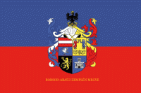
Borsod-Abaúj-Zemplén County (Borsod-Abauj Zemplen county)
 |
 |
Borsod-Abaúj-Zemplén is the second largest county of Hungary both by area (after Bács-Kiskun) and by population (after Pest County). It is the only Hungarian county with two UNESCO World Heritage Sites (the Caves of Aggtelek Karst and Slovak Karst and the Tokaj Wine Region Historic Cultural Landscape).
The county bears the name of three historic counties of Hungary, each of them was centered around a castle.
* Borsod is named after the castle to which it belonged. The castle was possibly named after its first steward, Bors (in old Hungarian language the -d suffix was a derivation suffix for place names, thus the name Borsod means 'place belonging to Bors.') The name Bors itself is of Hungarian origin, derived from the Turkish loan word bors, which means 'black pepper / peppercorn' or a Slavic personal name Bor(i)š, Borša. The castle itself was a motte castle, and stood near modern-day Edelény.
* Abaúj is a shortened form of the name of its castle, Abaújvár. The Aba portion refers to the Aba clan which ruled the area in the Middle Ages, while új vár means 'new castle.' The castle stood near the village of Abaújvár.
* Zemplén is named after its castle as well. The name is derived from the Slovak word zem or the Slavic zemlja, meaning 'earth, soil, ground' or 'country.' The castle, like its name indicates, was a motte with earthen walls; its remnants can still be seen near the Slovak village Zemplín.
Note that besides these three castles, there were other castles in the old counties which became the modern Borsod-Abaúj-Zemplén, such as the well-known Füzérvár.
Map - Borsod-Abaúj-Zemplén County (Borsod-Abauj Zemplen county)
Map


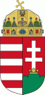
Country - Hungary
 |
 |
| Flag of Hungary | |
The territory of present-day Hungary has for centuries been a crossroads for various peoples, including Celts, Romans, Germanic tribes, Huns, West Slavs and the Avars. The foundation of the Hungarian state was established in the late 9th century AD with the conquest of the Carpathian Basin by Hungarian grand prince Árpád. His great-grandson Stephen I ascended the throne in 1000, converting his realm to a Christian kingdom. By the 12th century, Hungary became a regional power, reaching its cultural and political height in the 15th century. Following the Battle of Mohács in 1526, it was partially occupied by the Ottoman Empire (1541–1699). Hungary came under Habsburg rule at the turn of the 18th century, later joining with the Austrian Empire to form Austria-Hungary, a major power into the early 20th century.
Currency / Language
| ISO | Currency | Symbol | Significant figures |
|---|---|---|---|
| HUF | Hungarian forint | Ft | 2 |
| ISO | Language |
|---|---|
| HU | Hungarian language |


